9.3 km | 20 km-effort
Verdon : Sentier Blanc Martel
manumax
User
Length
16.1 km
Max alt
935 m
Uphill gradient
1683 m
Km-Effort
39 km
Min alt
556 m
Downhill gradient
1754 m
Boucle
No
Creation date :
2016-08-22 00:00:00.0
Updated on :
2016-08-22 00:00:00.0
6h43
Difficulty : Medium
FREE GPS app for hiking
About
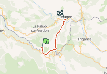
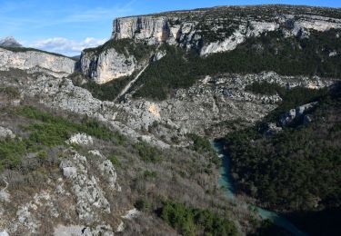
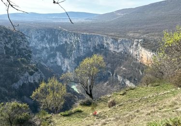
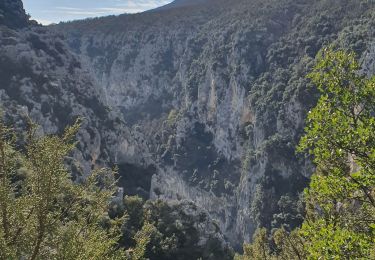
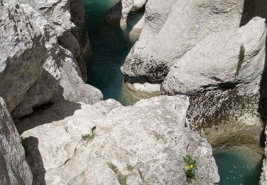
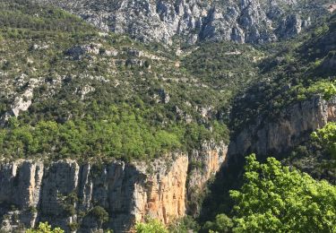
Trail Walking of 16.1 km to be discovered at Provence-Alpes-Côte d'Azur, Alpes-de-Haute-Provence, La Palud-sur-Verdon. This trail is proposed by manumax.
Description
Sentier Blanc Martel30/12/2014
Positioning
Country:
France
Region :
Provence-Alpes-Côte d'Azur
Department/Province :
Alpes-de-Haute-Provence
Municipality :
La Palud-sur-Verdon
Location:
Unknown
Start:(Dec)
Start:(UTM)
286342 ; 4847174 (32T) N.
Comments
Trails nearby
Belvédère, gorges, Inbut, sentier Vidal
Walking
Difficult
(3)
Aiguines,
Provence-Alpes-Côte d'Azur,
Var,
France
3h 35min
Yes
Sentier Blanc-Martel
Walking
Medium
(2)
La Palud-sur-Verdon,
Provence-Alpes-Côte d'Azur,
Alpes-de-Haute-Provence,
France
15.4 km | 31 km-effort
Unknown
No
bastidon
Walking
Medium
(1)
La Palud-sur-Verdon,
Provence-Alpes-Côte d'Azur,
Alpes-de-Haute-Provence,
France
18.4 km | 33 km-effort
Unknown
Yes
Chalet de la Maline - Point Sublime
Walking
Very difficult
La Palud-sur-Verdon,
Provence-Alpes-Côte d'Azur,
Alpes-de-Haute-Provence,
France
14.4 km | 28 km-effort
6h 19min
No
Sentier Blanc Martel
Walking
Difficult
La Palud-sur-Verdon,
Provence-Alpes-Côte d'Azur,
Alpes-de-Haute-Provence,
France
15.6 km | 31 km-effort
6h 57min
No
2023-03-24 Bastidon - Ravin du Brusc
Walking
Difficult
La Palud-sur-Verdon,
Provence-Alpes-Côte d'Azur,
Alpes-de-Haute-Provence,
France
13.3 km | 25 km-effort
5h 19min
No
Sentier de l'imbut
Walking
Medium
Aiguines,
Provence-Alpes-Côte d'Azur,
Var,
France
10.4 km | 27 km-effort
4h 0min
Yes
Gorges du Verdon - Sentier de l'Imbut
Walking
Very difficult
Aiguines,
Provence-Alpes-Côte d'Azur,
Var,
France
11.3 km | 33 km-effort
3h 35min
No
Verdon, le sentier Martel
Walking
Difficult
La Palud-sur-Verdon,
Provence-Alpes-Côte d'Azur,
Alpes-de-Haute-Provence,
France
13.2 km | 26 km-effort
5h 24min
No
très utile pour randonner par contre zoom pour imprimer sur pc peut être amélioré